MERROW DOWNS
A CHRONOLOGICAL HISTORY
COMPILED by
Merrow Residents’ Association
June 1991
MERROW DOWNS
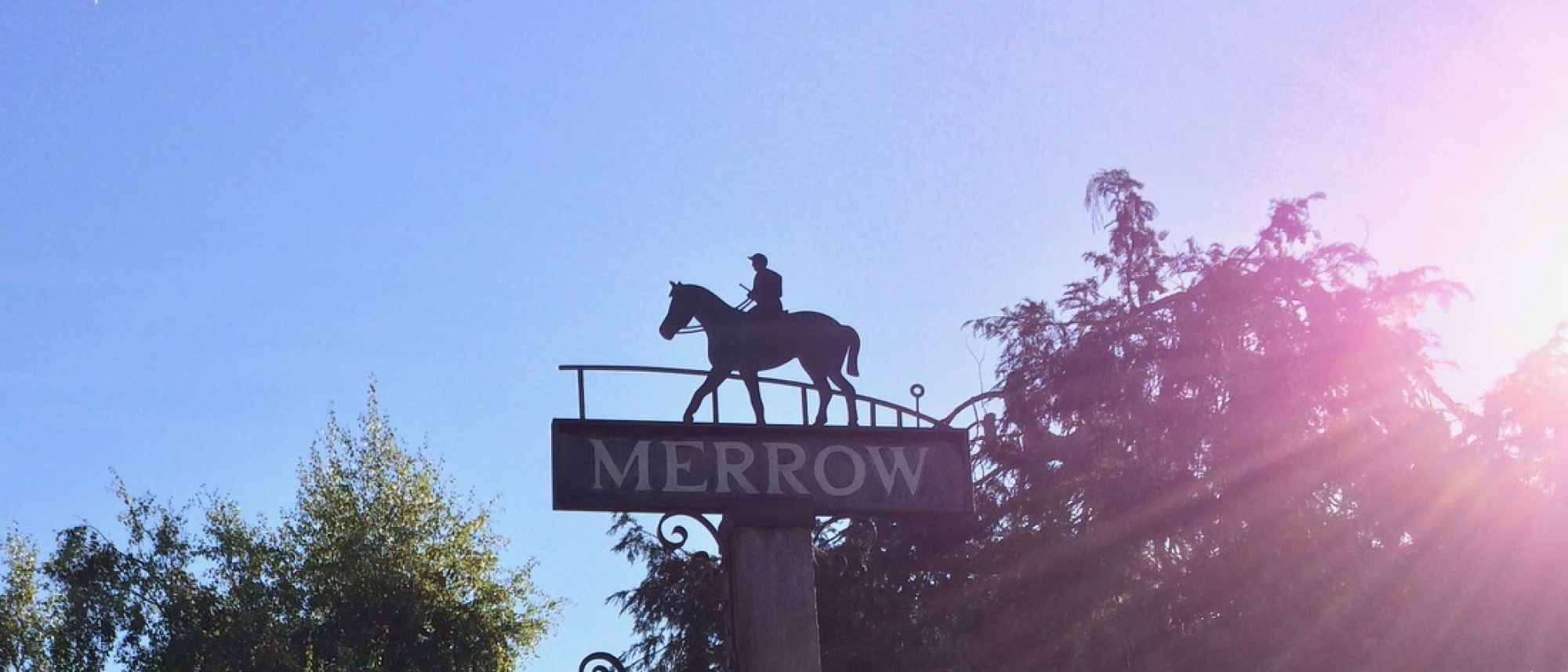
Merrow. Several theories have been put forward about the origin of the name. Its variations of spelling have been:
Merwe
Merewe
Mere-we
Mere-wy
Merroe
Merrowe
Mear-reaw
Possible explanations of its meaning are:
Mere – a lake or pool
Ewe – a yew tree (there are many old yew trees on the Downs)
Ewe – – Saxon word for sheep
Mear-reaw – – boundary row or ridge (the North Downs perhaps)
Mere-wy – – the way across the moor
1086 Domesday Book. Merrow is not listed in the Domesday Book. It was part of the lordship of Stoke which was ‘in the King’s park’ and a part of Woking Hundred. The lordship of Stoke was owned by King William.
Other places surveyed in 1086 in the immediate vicinity of Merrow were Guildford, Burpham, Send, East and West Clandon, Albury, Chilworth, Tyting and Shalford.
Past Owners of Merrow Downs
1100 to 1990. From about the year 1100 to the 1960’s the various owners of Merrow Downs were, among a number of others:
Henry I, the Conqueror’s youngest son
the Knights Templar
the Benedictine Priory of Ivinghoe in Buckinghamshire
the Priory of Boxgrove in Sussex
the Prior of the Hospital of the Knights of St John in England
1531 Sir Richard Weston of Sutton Place, by a Charter of Henry VIII, was given licence for 60 years to “empark 600 acres of land and pasture , 50 acres of woodland and 400 acres of furze and heath in the parishes of Merrow and Clandon.”
1555 Queen Mary restored the Order of the Knights of St John in England and granted the land to Sir Thomas Tresham, the Prior of the Order
1558 Priory dissolved. Reversion to the Crown – Elizabeth 1
1559 granted by the Crown to Sir Henry Weston
1593 Sir Richard Weston
1611 His son, Sir Richard Weston. It was he who introduced to England the system of river and canal locks and constructed the Wey Navigation Canal (1635-53) to link Guildford to the Thames. He was also an agriculturist and introduced water-meadows and the Flemish system of crop rotation including clover and roots.
1642 John Weston The year before, in 1641, Sir Richard Weston sold Clandon Park to Sir Richard Onslow. At some later date the Onslow’s extended their estate and acquired Merrow Downs from the Weston’s.
They then remained in the ownership of the Onslow’s until 1967.
Geology of the Downs
Merrow Downs once formed part of the bed of an inland sea. This was uplifted and eroded to form the North and South Downs and the Weald (so named from the Anglo Saxon word ‘wald’ meaning a forest). The Weald is composed of shaly clay and sands (the Hastings Beds) which are ideal for oaks and other strong trees and provide good arable farmland. Described in the simplest terms, Merrow Downs consist of a horizontal layer of chalk some 500 feet thick inclined upwards to the south at an angle of 10°. This layer ends abruptly at the south facing escarpment at Newlands Corner (567 feet). Below the chalk is greensand and this forms the lower greensand outcrop of the Weald – Leith Hill (965ft), Holmbury Hill (857ft), Coneyhurst Hill (Pitch Hill) (844ft) and Winterfold Heath (677ft). Parallel to the Guildford to Leatherhead road, in Merrow a few hundred feet to the north of it, is the southern edge of the bed of London clay. Where the clay and chalk meet is a line of springs along which the villages of Merrow, East and West Clandon, East and West Horsley, Effingham and Bookham are sited.
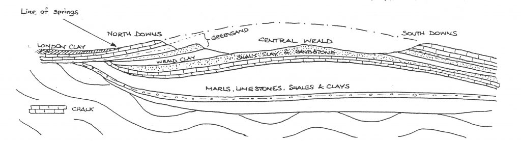
From a diagram in the fourth edition of the Institute of Geological Sciences’ Handbook “The Wealden District” published by HMSO in 1965,
Please see Geology-of-Surrey-with-diagrams by Surrey C.C.
Common Land, Rights of Common and Inclosure
‘Common’ has two meanings – a profit which a man has in the land of another and also a piece of land subject to rights of common. Such land is not owned by people at large who are entitled to wander over it but is usually owned by private individuals or bodies such as the National Trust or the Church Commissioners. The public has no automatic right to use the land for recreation although that right does exist on most commons today. Where it does exist there are, normally, byelaws for the regulation and management of the land. At some early stage in their history Merrow Downs, part of the waste land of the manor of Merrow, became a “common” because local people were given certain rights over it. Those having such rights were called commoners. The most usual right would have been when owners of cattle were entitled to put them to feed on the lord of the manor’s land (common of pasture). Rights of common also included the right to cut turf or peat for fuel on the owner’s land (common of turbary), the right to gather wood for house repairs, furniture, fences and fuel (common of estovers), the right to take gravel, sand, stone and other minerals from the soil (common in the soil), the right to turn out pigs at certain times of the year to eat beech nuts and acorns (common of pannage) and the right to catch fish (common of piscary).
Rights of common could be partially extinguished by a process known as approvement (appropriation). In the 13th century the lord of the manor was entitled to appropriate to himself and hold in separate ownership the manorial waste over which the freehold tenant had the right of common of pasture. He justified this on the grounds that because there were so many commoners the manor was unprofitable. ‘Approvement’ caused so much dissension that it was eventually regulated by law in 1235 and 1285. These laws allowed the lord of the manor to appropriate the manorial waste subject to the condition that he left sufficient pasturage for the commoners according to the number of animals they were entitled to turn out.
‘Approvement’ is still possible but has to have the approval of the Secretary of State for the Environment.
An alternative for the lord of the manor was to inclose the land. This allowed him, having reached agreement with all the commoners, to fence it in for the purpose of cultivation and free it from rights of common. In place of a commoner’s rights the lord could grant him, in exchange, a definite piece of land which would pass to his heirs. This process called inclosure could be applied to all rights of common and not just common of pasture as for approvement, it was little used not only because of the difficulty of reaching agreement but also because of the difficulty of tracing all the commoners and making them parties to the agreement.
By the late 18th century the greater part of the uncultivated land of England was still farmed under the medieval village community system. Rights of common generally obstructed cultivation and the productive employment of labour on the land. The system had outlived its purpose and was nothing but a hindrance. Mainly for this reason inclosure was now resorted to and over 4000 private and local Inclosure Acts were introduced by 1830. By 1860 inclosure had led to the almost entire disappearance of the rights of common which previously existed.
Through the Inclosure Acts between 1845 and 1875 some 590,000 acres were inclosed and divided among 25,930 people.
By 1865 there was great opposition to this form of land transfer to private ownership, the nation becoming convinced that one of the most urgent national needs was the provision of open spaces. The new policy was not to parcel out common land to private owners but to throw it open to the public and have it managed and regulated by public bodies.
Inclosure is still possible but it is unlikely that any application would ever be approved.
It is probable that the Earls of Onslow and their predecessors did appropriate some of the wasteland of Merrow Downs. Some of it may also have been inclosed and, if it was, that part would now be in private hands. The hare warren (see heading below) could be an example.
Rights of common on Merrow Downs certainly existed at the turn of the century but all have now gone, those entitled to them not wishing to claim them or having died without heirs. One right still remains on Merrow Common, the right held by one resident to graze a horse on a piece of land on the east side of Merrow Street.
DETAILED HISTORY FROM 1600
1670 John Evelyn. On 15 September 1670 John Evelyn (1620-1706), the diarist and author of memoirs who was born at Wotton, “went to visit Mr Arthur Onslow at West Clandon, a pretty dry seate on the Downes, where we din’d in his great room.” This would have been the original Elizabethan house. The present one was built between about 1730 and 1740. By 1670 Arthur Onslow was a Baronet inheriting from his father who died in 1664.
1700’s Hare Warren. During the early days of the Onslow’s time at Clandon a hare warren was built alongside Walnut Tree Bottom where hares were bred for hunting and food (hence ‘Warren Road’ and ‘Warren Farm’). The Onslow’s kept a private pack of harriers at The Grove, the huntsman’s house (later to be known as Levyls Grove and now Levylsdene) for hunting hares and foxes. The warren consisted of an area of several acres of an irregular quadrilateral shape enclosed by a six to seven foot high flint wall. The wall can still be clearly seen surrounding and extending to the south of Keepers Cottage in Walnut Tree Bottom. Two or three of the artificial ‘meuses’, which were about 5 inches square and built into the bottom of the wall, can also still be seen. ‘Meuses’ are the openings or gaps in a fence or hedge made by hares through which they habitually pass and through which they run for ‘relief’ when hunted. Keepers Cottage is to the south of and roughly in line with the 11th tee of the golf course.
Up to 1813 the inn at Merrow opposite the church was called ‘The Hare and Hounds’ which most probably related to the hare warren and the ‘sport’ of hare coursing which took place on the Downs.
The area along Walnut Tree Bottom near the hare warren was described on ordnance survey maps as ‘Fairyland’ local this name was used by local people until the 1930’s. John St Loe Strachey, who lived for some years at Newlands Corner, wrote in a booklet in the 1920’s that the place was “of the rarest beauty. It contains a group of yew trees which, whether seen by moonlight, sunlight, when the turf is green and covered with flowers, or, again, when it is spread with snow, makes it a place of wonder and delight.”
1822 William Cobbett (1762-1835), who was born at Farnham and made his ‘rural rides’ from 1821 to 1832, wrote in his diary for 25 September 1822 that he came to Merrow from Ripley. He was making for Chilworth but rather than going “on the level road to Guildford and come round through Shawford under the hills” and ‘having seen enough of streets and turnpikes” (there was a turnpike then in Merrow where Tollgate Cottage now stands and the Epsom Road east and west of it was called Upper and Lower Turnpike Road) ‘took across over Merrow Down where the Guildford race-course is, and then mounted the ‘Surrey Hills’, so famous for the prospects they afford.’ Cobbett was MP for Oldham from 1832 until he died.
1701 to 1870 Guildford Races
From 1701 to 1870 Guildford Races, flat and jump racing, were held annually in Whitsun week on Merrow Downs. The first official race was held in 1727.
The two mile racecourse ran along the north side of what is now the 10th fairway of the golf course, up past the north side of the 10th green and round towards the 14th green. It crossed the 3rd fairway near its teeing ground and ran eastward, parallel to the 3rd fairway and just to the south of it. The footpath below the ridge follows the line to Trodds Lane. It swung north east before crossing Trodds Lane, ran some 200 yards south east of the 7th green to within 45 yards of the Clandon / Newlands Corner road, swung north west round the ancient yew trees and back along what is now a diagonal path and right of way west south west across the 8th fairway, crossed Trodds Lane, ran up the 10th fairway and, finally, swung round to the east of the chalk pit and ‘through a part railed in to the stand to the termination’. The grandstand is believed to have been on the south side of the course at its western end a few yards east of the 12th green. There is an oil painting attributed to James Seymour (1701-1752) in the Green Drawing Room at Clandon Park titled “Harriers on the Downs near Guildford” which shows the stand and a small part of the course near the finish.
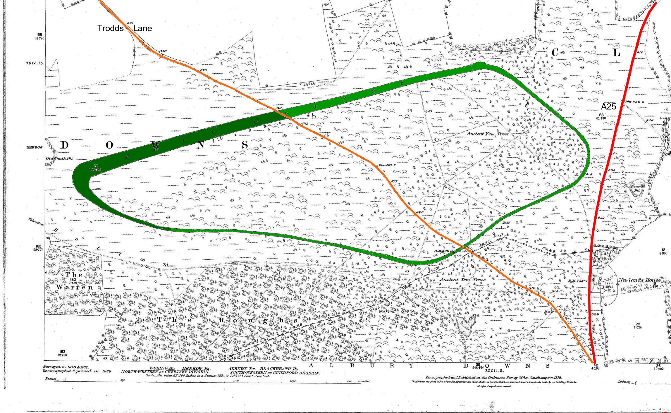
William III gave a King’s Plate of 100 guineas. This lapsed under Queen Anne but was renewed under George I. It was renamed the Queen’s Plate in Victoria’s reign.
On 15 June 1764 Gimcrack, a grey, won at Guildford. He won 26 races out of 36 in 9 years. The Gimcrack Stakes run at the August meeting at York every year is named after him.
The greatest racehorse of the 18th century, ‘Eclipse’, raced in ‘His Majesty’s 100 guineas for Horses, not more than 6 years old, carrying 12 stone, four mile heats’ at Guildford on 5 June 1770 which was one of the 18 races he entered as a five and six year old. He won them all, most with a walkover.
He was named ‘Eclipse’ because on the day of his birth, 1 April 1764, there was a total eclipse of the sun which could be seen from the east coast of Kent, Essex and East Anglia to a line from Norwich through London to Chichester, The Duke of Cumberland’s stud at Cranbourne Chase near Windsor and Ascot, where he was foaled, would have been only just outside the area of totality.
Jockeys could never hold him and all they could do was to sit on his back and let him win his races in his own way. He was never beaten, never had a whip flourished over him, or felt the tickling of a spur, nor was he ever for a moment distressed by the speed or rate of a competitor, out-footing, out-striding and out-lasting any horse which started against him. Over 90% of all modern thoroughbreds descend from his male line. He died on 28 February 1789 and a bronze sculpture by James Osborne was unveiled at Newmarket in 1989 to mark the 200th anniversary of his death. His skeleton can be seen at the Royal Veterinary College in Camden Town.
Before the institution of the Derby (1780) and the Oaks (1779) it is doubtful whether Epsom was more important than Guildford or Egham. The King’s Plate at Guildford was one of only eleven King’s Plates which were raced for in the country. The others were at Epsom, Newmarket (3), Nottingham, Lincoln, Winchester, Lewes, York and Black Hambleton (Yorkshire).
Racing at Guildford began to decline from the 1780’s in line with a general trend throughout England. There was a revival after the Napoleonic Wars but this did not extend to Guildford probably because Epsom and Ascot were more accessible and popular and because Guildford’s influential supporters had died out and the upkeep was too much for those who were left. Racing may have kept going because of the Queen’s Plate race, the last of which was held on Tuesday 26 April 1870. The grandstand, a wooden structure, was pulled down earlier in 1854 and burned outside Holy Trinity Church in one of the 5th November Guildford Guy ‘riots’ which were a fairly regular annual occurrence about that time.
1830 Walnut trees The walnut trees which lined an avenue called Walnut Tree Bottom which was a track from Levyls Grove to Keepers Cottage and beyond were cut down. The trees are clearly marked on John Rocque’s map of 1768.
1873 Colonel Lane Fox (who later became a Lieutenant General and changed his name, in 1880, to Pitt Rivers when he inherited the estates of his great uncle, George Pitt, 2nd Baron Rivers) excavated a mid 2nd century AD round Bronze Age barrow south east of Levylsdene and not far from Keepers Cottage in Walnut Tree Bottom. It contained a British urn and there were a number of holes filled with chalk rubble in the floor of the mound. The barrow may have been a short distance down the slope from the 2nd and 17th tees of the present golf course near Walnut Tree Bottom and was probably levelled when the course was first developed. General Pitt Rivers’ collection of weapons, implements, appliances, products of human life and archaeological discoveries is housed in the Pitt Rivers Museum at Oxford, established in 1883. He lived from 1873 to 1877 at “Uplands”, a house which is in the Epsom Road by Boxgrove traffic lights. In 1939 the property was taken over by Woodall & Duckham, designers of coke ovens for conversion of solid fuels to coke and other by-products, a Company which moved from London. In 1949 “Uplands” became the offices of the Ministry of Agriculture, Fisheries & Food with the old house forming the central part.
1876 Saxon barrows. Colonel Lane Fox excavated six Saxon barrows on Merrow Downs “in a cluster on the top of the hill just south of Level’s Dean”. Four contained evidence of burnt body and bone and one contained a Saxon knife blade. The position of these barrows was not recorded and is not now known precisely.
1886 Golf first played on Merrow Downs. The first Clubhouse was a private house in Down Road.
1887 Deed of Indenture (21 February 1887) issued by the Earl of Onslow giving Guildford Golf Club rights to occupy the land at a rental of one shilling per year.
1889 Deed of Grant. The Golf Club, in a Deed of Grant of 21 February 1889, was given by the Earl of Onslow exclusive rights free of disturbances to construct the links with putting greens etc. By 1889 an 18 hole course had been laid out. There was no official plan but this was remedied in 1901.
1889 Guildford Ladies Golf Club formed.
1890 John St Loe Strachey (1860-1927), who was the proprietor and editor of the ‘Spectator’ from 1898 until 1925, took Newlands House, near Newlands Corner in 1890 on a 6 month lease from Lord Onslow with a covenant to allow him to buy 2 acres of adjoining land at any time that the 6 month notice was given on either side. There was no post, no water and no noise. He was able to buy the 2 acres in 1891 and built on it a house which was named ‘Newlands Corner’. He and his wife moved there in 1892 and lived in it until 1925 when he retired from the ‘Spectator’. They sold it to a hotel company in that year. This house is now ‘The Manor at Newlands’ Hotel. Strachey chose the site because he considered that the view from it was “the best in England” and constructed a two storey belvedere in the garden so that he could take full advantage of the outlook. The belvedere is still in existence and can be viewed but is very dilapidated. The outlook is now completely blocked by trees.
After visiting Newlands Corner William Cobbett wrote in his diary of ‘rural rides’ on 25 September 1822
“here we look back over Middlesex, and into Buckinghamshire and Berkshire away towards the north-west, into Essex and Kent towards the east, over part of Sussex to the south, and over part of Hampshire to the Nest and south-west. We are here upon a bed of chalk, where the downs always afford good sheep food.”
This record shows how few trees there must have been at that time.
Strachey foresaw the inevitability of a European war and took up the registration of ‘Surrey Volunteers’ – ex soldiers and trained men. This scheme was copied beyond Surrey and by 1914 the War Office had a register of 250,000. He also took up Red Cross Voluntary Aid and rifle shooting as advocated by Lord Roberts. He joined Merrow & District Rifle Club, founded in 1870, which had its range in the West Clandon chalk pit.
The Strachey’s ran their house from April 1915 to March 1919 as a 24 bed Auxiliary Red Cross Hospital.
1891 A new Clubhouse for the Golf Club was built at One Tree Hill. This is now a private house.
1896 Burial ground. In the field just to the east of Downside many urns of 12 different types containing cremated interments were found. This field was considered to be a Romano-British burial ground and is marked as such on Ordnance Survey maps. It is now known as ‘Urn Field’. Two of the urns are in the Guildford museum.
At the time of the above discovery it was observed that “there are earthbanks on Merrow Downs of doubtful origin but generally regarded as Roman. They are situated in the valley, close to the gamekeeper’s cottage; there is an ancient Well nearby”. The earthbanks and the well still exist.
1901 Present Golf Clubhouse built. The Club purchased the land on which it now stands from its present southern boundary line down to Grove Road.
1901 Deed of Indenture (22 June 1901) extending the rights of the Golf Club, moving the course further to the east and abandoning the area to the west of the present Clubhouse up to Warren Road (this area is known as Brownings Down). This was the first lease which ran for 30 years backdated to 29 September 1899.
1901 Skulls and spearheads. A British skull was found near Copse Thorn Wood, which was close to the junction of Trodds Lane and the Clandon/Newlands Corner road, by Mr Walter Blake of the Hare Warren. The skull had a sword cut 2 1/4 inches long which passed through the bone. This had partially grown over indicating that the man had survived for some years afterwards. With the skull was found a 12 3/4 inch long Roman spearhead which was some evidence that the man was strong enough to perform his duties as a soldier. It is possible that he was a member of one of the tribes contemporary with the Roman occupation and was serving in a Roman legion. Both the skull and the spearhead are in Guildford Museum.
Nearby, though not close enough to be associated with the above finds, Mr Blake also found a shorter Iron Age spearhead.
1902 Rudyard Kipling published his ‘Just So Stories’. In the book he describes in verse the site where the ‘First Letter’ and ‘the Alphabet’ were made. Three of the eleven verses are:
There runs a road by Merrow Down
A grassy rack today it is –
An hour out of Guildford town,
Above the river Wey it is.
Here, when they heard the horse-bells ring,
The ancient Britons dressed and rode
To watch the dark Phoenicians bring
Their goods along the Western Road.
Of all the Tribe of Tegumai
Who cut that figure, none remain,
On Merrow Down the cuckoos cry
The silence and the sun remain.
Legend has it that the Phoenicians used the ancient trackway along the ridge of the North Downs to bring tin on the backs of mules from the mines of Cornwall while Walnut Tree Bottom was supposed to have once been a smugglers’ track. As shown on the 6 inch to the mile (1/10560) OS map of 1870 this latter track continued across the bottom of the present 17th and 1st fairways to Levylsdene. Here before ‘The Grove’ was built may have been an old farmhouse with extensive cellars, the destination of many valuables which were carried along ‘the grassy track’. Kipling probably heard these stories while he was staying with John Strachey in 1901 at his house near Newlands Corner and used them for his poem.
Kipling’s younger daughter Josephine died of pneumonia in New York in 1899 aged 7. Kipling himself contracted pneumonia at the same time which almost killed him. The final verse of the poem which was later titled ‘Merrow Down’ is a reference to his lost daughter:
For far – oh, very far behind,
So far she cannot call to him,
Comes Tegumai alone to find
The daughter that was all to him!
1904 Upkeep of the Downs. The Corporation of the borough of Guildford entered into an undertaking with the Board of Agriculture & Fisheries to contribute a sum of £50 per year for the maintenance of the Downs.
1904 Commons Regulations (Merrow) Provisional Order Act, 1904. This was initiated by the Earl of Onslow and drawn up by the Board of Agriculture and Fisheries under the Inclosure Acts 1845 to 1899; It laid down regulations for the Downs. For the improvement of the Common nine conservators were required to be appointed (2 by the Earl, 2 by Guildford Borough Council, 1 by Merrow Parish Council and 4 by the persons entitled to rights of common). For ‘the benefit of the neighbourhood’ there had to be reserved, among other things:
1 a right of free access at all times to the portions of the Common as shown on a map accompanying the Order and a privilege of walking, riding and enjoying air and exercise thereon.
2 a privilege of playing games on such parts of the Common as shown on the map as may be appointed by the conservators, with the proviso that this should be subject to the rights of the Golf Club.
also:
allotments mere to be set out’ for the purpose of supplying fuel and litter for the labouring poor of the parish of Narrow and
the yew trees on the Common, so far as possible, were to be preserved.
These allotments were established on the southern half of ‘Urn Field’ and were in use until well after the 1939-45 war.
1905 Deed of Indenture (10 July 1905). This was a supplementary lease for the Golf Club covering additional land. It ran from 29 September 1905 for 24 years.
1906 Byelaws for the Regulation & Management of Merrow Downs. These were made and issued by the Conservators. Reference is made in the document to a ‘Common Keeper’ who was employed by the Conservators to keep order on the Downs and see that the Byelaws were observed. Costs were paid from annual contributions made by the Town Council, the District Council and Merrow Parish Council.
1919 Guildford Town Golf Club formed. The demand from local people to play golf on the course could not be met by Guildford Golf Club. A new Club with separate management and Clubhouse was established for local trades people and shopkeepers of Merrow and Guildford only. It was limited to 100 members. Additionally, permits were introduced for those born or resident in Merrow allowing them to play golf on the course free. The number was limited to 30. Hours of play for Town Club members and permit holders were restricted.
1924 Deed of Indenture (29 November 1924). This amended the Golf Club leases of 1901 and 1906 extending them from 30 to 50 years and 24 to 45 years, respectively.
1925 Law of Property Act 1925. This was an Act to consolidate the various laws relating to ownership and transfer of property in England and Wales. Section 193 was relevant to the Downs because it was concerned with commons and waste land and the fact that owners could now impose limitations on their use.
1926 Agatha Christie. On 6 December an extensive search was started over the Downs and surrounding areas for Agatha Christie, the novelist (1890-1976). Police and dogs and aircraft were used. She had left her house at Sunningdale by car at 11 pm the night before. At Newlands Corner near a little quarry the car ran off the road into a small bush. It was found early next morning, 6 December, empty with minor damage. There was no sign of Mrs Christie. Nothing was heard of her for ten days when she was discovered at the Hydro Hotel at Harrogate. She had been staying there from the day of the accident. Just before her disappearance her husband had told her that he had fallen in love with another woman, Nancy Neale, a friend’s secretary. In the hotel register she used the name ‘Teresa Neele’. On the day of her disappearance a notice appeared in the Times:
Friends and relatives of Teresa Neele, late of South Africa, please communicate. Write Box R702 ‘The Times’.
It was established later that she had arranged for this notice to be published.
She either had a nervous breakdown, or suffered concussion and lost her memory when the car ran off the road and into the bush, or decided to ‘disappear’ after the accident to create a mystery. The true explanation was never established but many believe that ‘creation of a mystery’ coupled with some form of nervous breakdown was the most likely one.
Concern was expressed locally at the costs of the search operation and it was felt that Colonel Christie should pay them. In the event the Chief Constable sent him a bill for £25, the cost of the sandwiches and drinks for the Police during the search.
1931 Deed Poll (14 February 1931) In this Deed the fifth Earl of Onslow declared that Section 193 of the Law of Property Act 1925 applied to the land as leased course. Following this a draft Order of Limitation was drawn up.
1932 Public Enquiry (20 May 1932). This to the Golf Club and allowed him to widen the limitations on the rights of public access contained in the original leases. He wanted to do this because of difficulties over unauthorised people playing golf on the course. Following this a draft Order of Limitation was drawn up.
1932 Public Enquiry (20 May 1932) This was held to deal with a number of objections which had been received about the draft Order. As a result of this Enquiry some amendments to the draft were made.
1932 Order of Limitation This was the official Order which imposed by law ‘limitations on and conditions as to the exercise of rights of public access to the Golf Club land for air and exercise.’ It listed those persons who were not entitled to play golf on the golf course and, among other limitations, stated that “no person shall walk or ride over any part of the course so as to do damage to any of the putting greens or fairways”.
1930’s The ‘Common Keeper’ referred to in the byelaws of 1906, was now known by Merrow people as the Downs Keeper. He was employed by the conservators to ensure that the byelaws were being observed and to stop any disorder and vandalism.
Recreation Parts of Brownings Down (all that part of the Downs to the west of Guildford Golf Club’s present practice area) were used for cricket and football. Merrow Downs Cricket Club had their pitch at the western end near the footpath to the Ridgeway. The levelled area of the ‘square’ about 80 yards up from the footpath can still be seen. Below this the Congregational Church in High Path Road (now demolished) had its football pitch (The ‘Cons’ Football Club). At the top and of the present golf practice area was the pitch for Charlotteville Football Club.
Flying. The fields east of Warren Farm adjoining White Lane, sometimes known as Whites Field, were used occasionally for light aircraft flying and are believed to have been used also by Alan Cobham and his flying circus. He gave flying displays and local flights for ten shillings a trip.
1940 Prisoner of War Camp. The War Office constructed a camp on Brownings Down to house Italian prisoners of war. The entrance road, around which the soldiers guarding the camp were housed and where dog walkers now park their cars, and an outline of the foundations of the huts and the camp football pitch are still visible. The Italians were repatriated when the armistice with Italy was signed in 1944 and the camp was then used to hold German prisoners until 1945.
Allotments During the war an anti aircraft gun was positioned on Urn Field. The Urn Field allotments continued to be used despite some damage inflicted by a small German bomb dropped on them during an air raid.
1945 Temporary Housing When hostilities ended there was an acute shortage of housing throughout the country. The concrete huts of the prisoner of war camp were turned over to temporary housing and were used as such until 1952-53 when Bushy Hill estate was built. The huts were then demolished and the rubble was used as in-fill for the old chalk pit in York Road, Guildford.
1949 National Parks & Access to the Countryside Act. This required local authorities to produce maps and statements defining the rights of way in the area. Such a map was produced for the Merrow area.
1950 The two deeds of indenture (leases) for the Golf Club expired and a new one dated 18 October 1950 was issued to run until 1971.
1951 A new Order of Limitation was issued with no significant change from the original one of 1932.
1954 Outbreak of myxomatosis. From 1870 farming in England steadily declined with competition from abroad and few sheep were grazed on the Downs. Trees could now grow if planted or if seeds, spread naturally, took root. Scrub and thorn were held in check in some degree by the rabbits. With the depletion of the rabbit population from 1954 the natural succession to coarser, woodier plants progressed with bracken, gorse and scrub getting a firmer hold. Had it not been for the management of the golf course the Downs would, by now, be very much more overgrown.
Photographs of the Downs taken in the 1920’s confirm that most areas which in 1990 are wooded or covered with thorn or gorse were nearly all open at that time with few trees or scrub.
Most rabbits have now grown resistant to the myxomatosis virus but there is still evidence of it existing in the area.
1957 Saxon spearhead. An early Saxon (500 AD) spearhead and human remains were found in the garden of a house in Levylsdene.
1958 Golf Club 9th fairway. The Golf Club purchased from Lord Onslow for £100 a parcel of land which forms the major part of the 9th fairway. Remains of a low flint wall can be seen in several places and gives some indication of the original boundary. It is marked on the OS maps prior to 1960. This land was not included in the original lease but Lord Onslow had allowed the Golf Club to use it when the course was extended to the east of Trodds Lane in the 1930’s. In 1958 he offered for sale several parcels of land which he no longer required and this was one of them. The Golf Club bought it given the price and the opportunity to avoid having an alien tenant.
1964 Access track car park. The Golf Club was granted planning permission by Guildford Borough Council to extend the access track just beyond the western boundary of the Clubhouse 40 feet to the west and fill with hardcore, to allow more cars to be parked.
1965 Commons Registration Act. This resulted from a Royal Commission set up in 1955 for the future use of common land. The Commission’s conclusion was that all common land should be registered. Commons are regarded by the Act and by the Ministry of Agriculture, Fisheries & Food primarily as a public amenity but ‘the registration takes due attention of all existing proved legal rights either in the soil or of user over the surface.’ No land capable of being registered under the Act is deemed to be common land or a town or village green unless it is registered and no rights of common are exercisable unless the land is registered.
The Act came into operation on 2 January 1967 (for village greens it was August 1967). The cut-off date for registration was 3 years from those dates.
Any land not registered as common land by the above dates but, subsequently, becoming common land could be registered as from 20 years after those cut-off dates (1990 onwards).
Surrey County Council keeps a register of commons in Surrey, the details of their owners (in most cases it is only the HM Land Registry Title Numbers) and the rights of common existing over such land.
Registered common land may not be fenced, be built on or have car parks except with approval of the Secretary of State for the Environment.
1967 Guildford Borough Council on 4 July 1967 purchased Merrow Downs from the Earl of Onslow subject to the lease of the land to the Golf Club.
1967 Guildford Corporation Act 1967. This gave normal management powers to the Council which it required to administer land on behalf of the people of Guildford. For Merrow Downs it allowed the Council to:
1. execute any necessary works for the protection and improvement of the common;
2. plant trees and shrubs for the purpose of shelter or ornament;
3. construct plantations
4. set out, construct and maintain footpaths and roads as they considered expedient or necessary for the enjoyment of the common by the public;
5. set apart, for the purpose of games, sports or entertainment, a portion or portions of the common as they considered expedient, and allow such portion or portions to be temporarily enclosed with an open fence;
6. use, with the consent of the Secretary of State, any part of the common for the construction of public walks, parks, pleasure grounds or for other purposes;
7. do nothing, save as hereinbefore provided, that may otherwise vary or alter the natural features or aspects of the common, and shall not construct on the common any shelter, pavilion, drinking fountain, convenience, car park, building or permanent fence without the consent of the Secretary of State;
8. make byelaws for the regulation and preservation of, and the preservation of order on, the common and such byelaws may provide for the removal of any person infringing any such byelaws by any officer of the Council or a police constable.
1968 Countryside Act. This act required local authorities to carry out a special review of all public paths, to be classified under three heads – byways open to all traffic, bridleways and footpaths. Such a review was carried out on Merrow Downs but local people were not consulted. Among the many bridleways and footpaths existing some were accepted and others were not. A notable omission was the bridleway/footpath following much of the east/west line of the old racecourse along its southern side, a path which is still well used. Redrawing of the definitive map was started and is expected to be available for sale to the public during 1992. A master copy for the Merrow area can be viewed at West House, Merrow Lane (Surrey County Council Rights of Way Officer – Tel: Guildford 503151).
1968 Walnut Tree Bottom. Under the Commons Registration Act the new owner of Keepers Cottage in Walnut Tree Bottom registered the pre-existing right of the owner of the Cottage to use a motor vehicle for access to it along the bridleway from the Golf Clubhouse; also for others requiring legitimate access to it to have a similar right.
1968 Golf practice area. The Golf Club’s western boundary of part owned and leased land was the boundary fence immediately to the west of the Clubhouse continuing in a straight line south to the boundary fence of the Downs. About this time the Club started to use, unofficially, some land to the west of this as a practice area. This generated some complaints from local people.
1969 Golf practice area. At a meeting of Guildford Borough Council on 10 September 1969 the Culture & Recreation Committee agreed to include in the new lease with the Golf Club (due for renewal in 1971) ‘the practice area at present being used for this purpose”. This was a strip of land to the west of the pathway from the access track to Keepers Cottage extending due south to the boundary of the Downs. Before the meeting was held the Borough Engineer was asked to provide a plan showing the area already being used for practice by the Golf Club. The plan which was drawn and submitted included the access track used by the public and golfers for access to the Downs and for parking cars outside the Clubhouse boundary fence and all that land extending north from the practice area to the pathway across the Downs from Grove Road to One Tree Hill.
1970 Commons Registration. Final registration of Merrow Downs by Guildford Borough Council under the Commons Registration Act 1965.
1970 Trodds Lane. With the increasing volume of traffic using this Lane (A25) for access to and from the Dorking direction Surrey County Council proposed a spur road cutting through St John’s Church Rectory. This was strongly opposed by Merrow residents some of whom favoured an alternative that the Lane should be made into a cul-de-sac and that all traffic be diverted via Clandon crossroads.
1971 Trodds Lane. Width restriction of 6ft 6in introduced for traffic proceeding from Merrow towards Newlands Corner.
1973 A child’s skeleton, probably Saxon, was found in a shallow chalk-cut grave in the garden of a house in the Fairway.
1973 Golf Club proposal for a new Clubhouse. The Golf Club proposed to build a new Clubhouse on the west side of Trodds Lane adjacent to the 6th green – some 200 yards beyond the last house in Trodds Lane – giving up the 1st, 17th and 18th holes and building three new holes on 25 acres between the new Clubhouse and Newlands Corner. It was hoped to exchange the land taken up by the 9th fairway and owned by the Club to part compensate for these 25 acres. The Clubhouse and the Golf Club land up to Grove Road would be sold for development, the amount realised being used for erection of the new Clubhouse. The main advantages claimed to be were:
• The practice area and the 1st, 17th and 18th holes would become available to the Council for alternative use;
• Clubhouse in the centre of the course;
• Reduction of traffic in High Path Road;
• More centralised supervision and control by the Club staff of the work of maintaining the Downs and keeping an eye on vandalism.
Objections to the proposals were:
• increased traffic in Trodds Lane;
• the possible type of development on the site of the existing Clubhouse;
• intrusion into common land and Green Belt by the erection of the new Clubhouse.
At Merrow Residents’ Association AGM in November 1973 over 80% of those attending voted against the proposal.
1974 Application by Guildford Golf Club for a new Clubhouse in Trodds lane turned down by Surrey County Council on the grounds of increased traffic hazards in Trodds Lane.
1974 New lease for the Golf Club dated 17 October 1974 drawn up, backdated to 29 September 1971, to run for 21 years until 1992.
NOTE 1: Accompanying this lease was a 1/10560 Ordnance Survey map showing the boundary of the leased area which included the additional practice area as drawn by the Borough Engineer for the Committee meeting of 10.9.69. The distance of that boundary from the Clubhouse fence was 60 metres.
NOTE 2: The Earl of Onslow’s lease had specified the boundary of the land leased in terms of an area of so many square yards from each tee. The new lease showed the land leased as a coloured area on a map which included all of Merrow Downs with the exception of three areas each of some 40 acres:
to the east – the woods to the east of the 8th fairway
to the west – Brownings Down
to the south – the Roughs.
1974 Amalgamation of Guildford Golf Club and Guildford Town Club
1974 Byelaws. On 1 January 1974 new Byelaws under Section 39 of the Guildford Corporation Act 1967 (see paragraph 8 under ‘1967’, above) were made and issued. These superseded those made by the Conservators on 20 April 1906 as required by the Commons Regulation (Merrow) Provisional Order Act, 1904.
1974 Order of Limitation made 14 October 1974 expiring in 1992. This had an accompanying plan showing the area which it covered and was in line with the plan accompanying the new lease of 1971 for the Golf Club (see above).
As for the Order of 1932, the 1974 Order listed the limitations and conditions to which the rights of access of members of the public to the land for air and exercise were to be subject. These are:
• that persons who are not members, or guests of members, of the Guildford Golf Club or Guildford Ladies Golf Club or a professional golfer, caddie or other person authorised in each case by the Guildford Golf Club may not play on the course;
• that no person shall walk or ride on the course so as to damage putting greens or fairways;
• that no person shall wilfully – disturb the soil or turf
• destroy, chase, or take or set traps or snares for any wild animals.
This was similar to the earlier Orders of 1932 and 1951.
Notices of the making of the Order were required to be posted or painted and maintained in that condition by Guildford Borough Council at four specified positions on the land.
1979 Trodds Lane. With the completion of the dual carriageway from Clandon Park gates at Merrow to Clandon crossroads a width restriction of 6ft 6in for traffic using Trodds Lane in either direction was introduced. At the same time the Lane was declassified and the road from the Trodds Lane turn off at Newlands Corner to Clandon became the A25. Traffic was now signposted to and from Newlands Corner/Merrow via Clandon crossroads.
1980 Lease renewal The Golf Club asked the Council for an option to renew the lease for a further 21 years when it was due to expire in 1992. As an alternative, the Council agreed to grant a new lease from 1981 expiring in 2013.
1981 Saxon beads. Six were found in the garden of a house in Levylsdene.
1981 New lease for the golf club drawn up to run until 2013. The yearly rental is £225. This is to be reviewed in 1992 and every seventh year thereafter. The terms and conditions are little changed from previous leases, the main ones being, namely:
Use of the land by the Club is intended to be entirely subordinate and without prejudice to the common and public rights existing.
The Club is required:
• to exercise adequate control and supervision over the land;
to manage and maintain the land in a husbandlike manner;
• not to cut down or injure any trees, plants, bushes or hedges or remove any soil, clay, sand or other material without the Council’s previous written consent;
• not to make any excavations without the Council’s written approval for the purpose of laying out and maintaining the golf course;
• not to erect on the land any dwelling house, fence or other building and make no other alteration in the character and general arrangement of the land other than that which may be desirable for laying out and maintaining the golf course, as approved by the Council in writing;
• not to create or form any roads or vehicular access ways and not to permit any parking other than on the area in front of the Club House (i.e. the access road beyond the boundary of the Club House on its western side for which planning permission was granted in 1964).
• residents of Guildford to be allowed to play golf on the land in return for green fees which shall not exceed, per day,
for adults – 7/97 of the full member’s subscription;
for those under 18 – 1/10 of the under 18’s annual subscription.
1983 Guildford Borough Local Plan Proposals map shows Merrow Downs within a larger area extending to the Clandons and the North Downs as one of ‘high ecological importance’ (now known as an ‘area of high ecological quality’ (ANEW, This classification, which for Surrey is made by the Surrey Wildlife Trust (previously the Surrey Trust for Nature Conservation) in conjunction with the Local Authority, is concerned with flora and fauna. The Trust considers that the area merits protection in line with Local Plans and has to be consulted on all applications for development of the Downs. This is with a view to protecting the features for which the area is important, ie ‘a large area containing good examples of chalk and downland and woodland habitat types’. A list of some of the wild flowers found on the Downs is included at the end of this ‘history’.
1984 Permissive bridleway. In May 1984 Guildford Borough Council agreed that the track from the south west corner of Brownings Down along the top boundary of the Down to Walnut Tree Bottom should become a ‘permissive’ bridleway. This was a long established track but had not been included as a bridleway on the definitive map published by Surrey County Council. It was now accepted by the Borough Council as an official path.
1985 Surrey Act 1985 The purpose of this was to re-enact various pieces of local legislation which would cease to have effect at the end of 1986 under the Local Government Act 1972. The section relating to Merrow Downs is a straightforward reprint of the relevant section in the Guildford Corporation Act 1967 (see above).
The Act gives the area of Merrow Downs (which is outlined on the map on page 15 of this history) as 155.96 hectares (385 acres).
1985 Closure to vehicles by Guildford Borough Council of the track across Brownings Down from High Path Road/Grove Road to One Tree Hill. This was done by the Council as part of the enforcement of the byelaws.
1985 The Golf Club applied to the Council for permission to extend the access track outside the fenced boundary of the Clubhouse 14 metres to the west to accommodate an additional 58 spaces for parking cars. The Council recommended that approval be granted. The application also required the consent of the Secretary of State for the Environment (see above under ‘1967’, paragraph 6). The scheme was not progressed due to lack of funds at that time and a planning application was not submitted.
1987 A management plan for the golf course land was commissioned by the Golf Club and, following discussion with the Arts & Recreation Committee, the Surrey Wildlife Trust and other interested bodies, it was approved by the Council. The objectives are to:
1. preserve the open scenic beauty of the area for all concerned;
2. conserve the natural flora and fauna of the area in so far as available resources permit;
3. enhance the beauty of the area by encouraging and where necessary planting suitable trees and shrubs;
4. ensure that the trees / shrubs do not unreasonably interfere with the playing of golf.
The plan divides most of the areas alongside the fairways into ‘compartments’ and gives a brief description of each together with the improvements which are recommended. It is progressed as opportunity and finances permit.
1988 The access track outside the fenced boundary of the Clubhouse tar macadamed at a cost of £20,000. The Arts & Recreation Committee had approved at its meeting on 3 September 1987 that the Council should pay £7,500 of this amount, the Golf Club paying the remainder.
1988 Yew Trees. There are several hundred yew trees on Merrow Downs and some, which are all male, are very old with girths of over 20 feet. One of the trees, in a group south of West Clandon Wood, has a girth of 22 feet and has a service tree with a girth of 4 feet 4 inches growing from the centre of it. Another in the same group has a girth of 22 feet 6 inches and is hollow. A third, in a grove some 40 yards away, has a girth of 23 feet 5 inches. Two others, in a grove at the eastern end of Walnut Tree Bottom, have girths of over 22 feet. One of these is hollow. Special reference was made to these trees in the Commons Regulations (Merrow) Provisional Order Act 1904 – “the yew trees on the said Common shall so far as possible be preserved by the conservators”
Following a 1981 survey a document signed by Robert Runcie, Archbishop of Canterbury and David Bellamy, Allen Meredith and Robert Hardy was issued in 1988 by the Conservation Foundation certifying that ‘using all the data we have to hand the age of the yew tree at Newlands Corner, Merrow Downs is 2000 years old’. A copy of the document is fixed to the tree with the service tree growing from the centre of it (see previous paragraph). The other large trees referred to above are most likely to be of the same age. To one of these written under the shade of its branches belongs the following verse of a poem The Father of the Forest by William Watson:
Old emperor Yew, fantastic sire,
Girt with thy guard of dotard kings,-
What ages hast thou seen retire
Into the dusk of alien things?
What mighty news hath stormed thy shade,
Of armies perished, realms unmade?
It is probable that before Christianity yews were regarded as sacred trees and it has been suggested that the groves on Merrow Downs may have been part of some ancient graves. Caesar recorded that the Druids preached a doctrine of immortality of the soul and regarded the yew as a symbol of that immortality. Certainly the yew is a commoner tree than, say, the oak in the Iberian Peninsula where these pre Celtic people came from and it is possible that they brought to these islands the cult of the yew – or at least the custom of using yew groves for their religious rites.
The yew seed and foliage, though not the succulent red cup or aril which surrounds the seed, are poisonous for most animals except deer.
The yews on Merrow Downs are not referred to in the Domesday survey as several writers have claimed they are. This misunderstanding may have come from the survey record for the Manor of Clatinge in Fordingbridge Hundred in Hampshire.
The survey had to record for each landowner how much woodland, among other things, he held and this was given as the number of pigs the woodland was able to support. For Clatinge the record shows silvae inutilis which means ‘useless woodland’. The assumption is that the land was unfit for pigs because the trees were yews. Clatinge is a lost Manor and the nearest village to it now is Goodworth Clatford just south of Andover.
Yews were grown for longbows, which were fashioned from the straight trunk, for the bowmen of England and some of the trees on the Downs may have been planted for that purpose. English yew, though often used for spear shafts was, however, regarded as too brittle and knotty for bows and the best was imported from Spain, France and Italy.
1988/89 Protection of flora and fauna on the Downs As part of a national survey all the chalklands in Surrey were surveyed by the Nature Conservancy Council. Chalk grassland is internationally endangered. Brownings Down was identified as an area of importance ecologically and a strong recommendation was put forward to classify it as a Site of Special Scientific Interest (SSSI). This classification is concerned with flora and fauna and is one step up from an ‘AHEQ’. If the classification is adopted it will be a requirement that Guildford Borough Council manages the land as recommended by the NCC and consults the NCC on all planning applications which might affect the area. The NCC is the body responsible for advising Government on nature conservation in Great Britain.
1990 Guildford Borough Council Local Plan Deposit Version October 1990 shows Merrow Downs within an area extending to Shalford, Peaslake, Abinger, Effingham, Horsley and Clandon designated as an ‘Area of Outstanding Natural Beauty (AONB). This is an environmental classification and is made by the Countryside Commission with Local Authorities. It confers special development control status.
The Local Plan map shows the AONB to be within a larger area designated an ‘Area of Great Landscape Value’ (AGLV). This, also, is an environmental classification but is allocated by the County.
1990 Access track car park extension. The Arts & Recreation Committee considered an application from the Golf Club to extend, at no cost to the Council, the present facilities for parking cars on the access track to the Downs (now 95 spaces) so that there will then be 123 spaces. This was approved by the Committee subject to a planning application and approval and the approval of the Secretary of State for the Environment.
Some of the wild flowers found on Merrow Downs and in the beech woods at the eastern and northern end:
| clustered bellflower | birdsnest orchid |
| cowslip | common spotted orchid |
| oxeye daisy | common twayblade orchid |
| dropwort slender | early purple orchid |
| false-brome | frog orchid |
| upright brome | pyramidal orchid |
| red fescue | wild parsnip |
| tor-grass harebell | hoary plantain |
| self-heal broad helleborine | small scabious |
| narrow helleborine | dwarf thistle |
| black knapweed | early flowering thyme |
| spurge laurel | bastard toadflax |
| false-oat | horseshoe vetch |
| meadow oat | kidney vetch |
| bee orchid | hairy violet |
| wintergreen |
By Members of the Merrow Residents’ Association.
May 1991.
Click here for a map of Merrow Downs 1934